O in short: TRANSDAT Coordinate Conversion supports thousands of coordinate systems and geodetic datum shifts user-defined systems INSPIRE NTv2 BeTA2007 GPS continental drift many file systems ESRI-Shape great
|
 Categories Categories |
|
|
|
|
|
TRANSDAT 15.10 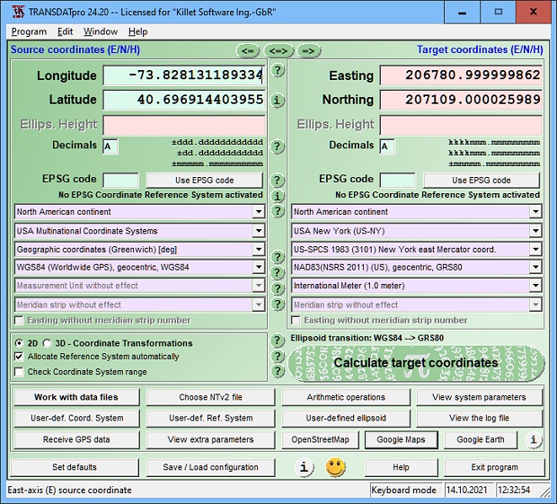
Click to enlargeDescription:TRANSDAT geosoftware executes coordinate transformations and geodetic datum shifts between many coordinate and reference systems of America, Australasia, Europe, Germany special and world-wide, at high precision and high speed: 1.The current and historical coordinate and reference systems of all countries of the European Union (EU) including the eastern extensions and the systems of non-EU countries. 2. The INSPIRE supported European ETRS89 systems. 3. The US and Canadian State Plane Coordinate Systems (SPCS) on NAD27 and NAD83 and other coordinate systems of the North American continent. 4. The coordinate and reference systems of the Australasian continent. 5. Many coordinate and reference systems of the countries of other continents. 6. World-wide NTv2 grid file supported coordinate transformations. 7. All global coordinate and reference systems. 8. The German coordinate and reference systems of the old and new federal states, the 40 Prussian Soldner Land Registers, the German Lagestatus, and exact reference systems of the German federal states. You will find a complete list of the coordinate and reference systems supported by the program on the web or after downloading the free test version of the program. The NTv2 standard with national grid files is world-wide full supported. Apart from the given world-wide and state-specific systems, your own personal coordinate systems and geodetic reference systems can be defined with Helmert (Bursa / Wolf, ISO 19111) or Molodensky parameters. Calculations can be performed with coordinates entered directly, loaded from files in various formats (Text, CSV, SDF, dBase, ArcShape, ArcGenerate), or passed by batch processing. ArcShape files can be viewed with the internal Shape Viewer. A programmable GPS interface makes it possible to read coordinates from a low-cost GPS antenna. The program can be run on a network, in which case clients are installed automatically. The program has a multilingual interface.
 | Price $ 100 / 150.00

Purchase TRANSDAT
Get it Now(to see additional options, click Buy Now) Type: Shareware File size: 2465 Kb Date: 02/10/2012 HomepageInstall support: Install and Uninstall OS: WinXP, WinVista, WinVista x64, Win7 x32, Win7 x64, Win2000, WinOther, Windows2000, Windows2003, WinServer, Windows Vista Ultimate, Windows Vista Ultimate x64, WinMobile, Windows CE, WinME, WinNT 3.x, WinNT 4.x, Windows Tablet PC Edition 2005, Windows Media Center Edition 2005, Windows Vista Starter, Windows Vista Home Basic, Windows Vista Home Premium, Windows Vista Business, Windows Vista Enterprise, Windows Vista Home Basic x64, Windows Vista Home Premium x64, Windows Vista Business x64, Windows Vista Enterprise x64, Windows Mobile 2003, Windows Mobile 2005 System requirements: 500 MHz, 500 MB Memory, 100 MB HD Language: English, French, German, Greek, Portuguese, Spanish Recent changes in this Major Update:Stores user data in separate directory. Supports encrypted NTv2 files. New NTv2 grids of Austria, Spain, Portugal, Germany and Switzerland. New Systems for Denmark, Sweden and Australia. Display of coordinates in GoogleMaps and GoogleEarth. Output of windows contents in GIF/BMP files. | |
|