O in short: a International - World-wide database of countries with georeferenced towns municipalities postal codes and administrative units with WGS84 and UTM coordinates and elevations for geocoding proximitversatile
|
 Categories Categories |
|
|
|
|
|
Geodata International 5.03 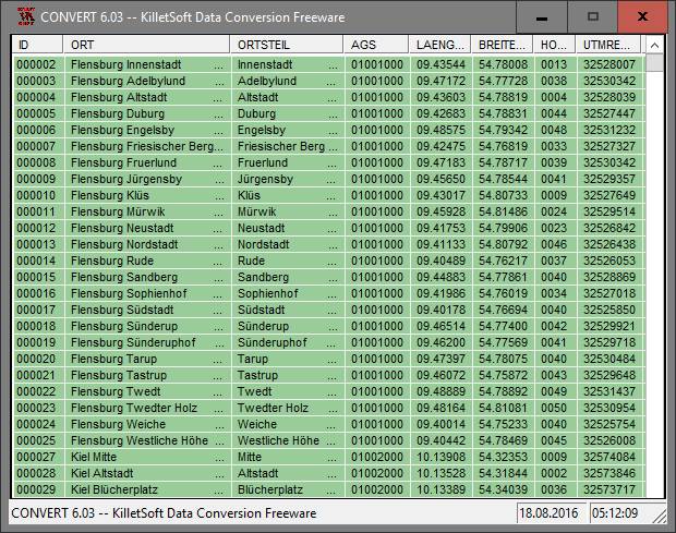
Click to enlargeDescription:Geodata International - World-wide database of countries with georeferenced towns, municipalities, postal codes and administrative units with WGS84 and UTM coordinates and elevations for geocoding, proximity search, navigation, distance calculation. There are database tables from more than 160 countries. Often is it necessarily, for an address characteristic, e.g. the place name or the postal code, to establish a local relationship - a georeference. The georeference can be used e.g. to show a customer the nearest chain store by doing a proximity search. On the basis of the georeferences business zones, statistics or general maps can be made. Towns, municipalities and postal codes can be assigned to the superordinated administrative units. Distances between places or postal areas can be determined with the coordinates contained in the database tables. For that the georeferences are available in all country database tables as UTM coordinates on the natural and an uniformly meridian strip and as geographical coordinates in degree and deg/min/sec notation. With the elevation data from a Digital Elevation Model the ground level height of each place can be determined. The database tables are present in the file format CSV (Comma Separated Values). The character set used is UTF8. This format is used often and in most cases you can import data directly into your own data system. The freeware program CONVERT, downloadable from the KilletSoft site, converts the available database tables to other data formats and character sets with the necessary sortings and selections. With the program, for example, CSV data can be converted to the SDF format (Simple Document Format) or to the dBase format. For the use of the data on different platforms it is possible to select between the character sets ASCII, ANSI, UTF8 and UniCode. Thus the import of the data in any database management system or file system will be possible.
 | Price $ 190.00 / 150.00

Purchase Geodata International
Get it Now(to see additional options, click Buy Now) Type: Data only File size: 791 Kb Date: 04/12/2013 HomepageInstall support: Install Only OS: Java, Linux, Mac Other, MS-DOS, Unix, Win2000, Win7 x32, Win7 x64, Win98, WinMobile, WinOther, WinServer, WinVista, WinVista x64, WinXP, Other System requirements: All systems Language: German, English, French, Italian, Dutch, Portuguese, Spanish Recent changes in this Major Update:Database Germany and Italy updated to actual date Januar 2013. Databases of Austria updated to actual date November 2012. Databases of 13 countries added. 129 Countries updated on actual date April 2012. Databases sorted by country specific character sets. | See also in:
| Business and Finance: Business and Finance:Miscellaneous and all-in-one | |  | Word Viewer is an easy-to-use Free Word Viewer,You can read Word 2010,2007,Word 97~2003,html,txt,rtf. You can convert Word 2007(docx),Word 97~2003(doc),Txt,Html,Rtf to PDF,DOCX,DOC.It is a multilingual software. |
|
|
|