O in short: onverter is a powerful converter of GIS files. It converts AEP GRD ADF E00 FLT APR SHP DXF and many other GIS formats to TIFF PNG JPEG BMP. Along with conversion it can scale and raffordable
|
 Categories Categories |
|
|
|
|
|
Total GIS Converter 1.5 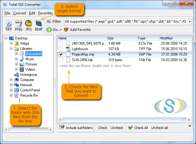
Click to enlargeDescription:Total GIS Converter is an affordable converter of GIS files. It converts AEP, GRD, ADF, E00, FLT, APR, SHP, DXF, BT, TOC, RT1, DEM, DLG, ECW, IMG, DGF, GML, SID, MIF, TAB, WOR, DNG, DDF, BIL, TIF, JPEG, TTKPS, TTKGP, TTKLS, LFT, PFT, and TFT files. The target formats are TIFF, PNG, JPEG, BMP. The program can scale your GIS files to optimize their size. Besides, it can slice the output files to several parts. Total GIS Converter has easy-to-understand interface plus command line support. Try it for free. Download the trial version now and convert your GIS files.
 | Price $ 99.90 /

Purchase Total GIS Converter
Get it Now(to see additional options, click Buy Now) Type: Shareware File size: 7772 Kb Date: 03/01/2013 HomepageInstall support: Install and Uninstall OS: WinXP, WinVista, WinVista x64, Win7 x32, Win7 x64, Windows2000, Windows2003, Windows Vista Ultimate, Windows Vista Ultimate x64, Win98, WinME, Win95, Windows Vista Starter, Windows Vista Home Basic, Windows Vista Home Premium, Windows Vista Business, Windows Vista Enterprise, Windows Vista Home Basic x64, Windows Vista Home Premium x64, Windows Vista Business x64, Windows Vista Enterprise x64 System requirements: A standart windows PC Language: English Recent changes in this Major Update:New version supports more output file types. | See also in:
| Graphic Painting and Drawing: Graphic Painting and Drawing:Miscellaneous and all-in-one | |  | Able Fax Tif View is a FAX and TIFF viewer and converter, offers you a full solution for viewing, editing, printing, saving, converting.Able Fax Tif View can convert FAX and TIFF files to standard TIFF/FAX format, jpeg, png, bmp, pcx, gif, dib, rle |
| |  | Total GIS Converter is a powerful converter of GIS files. It converts AEP, GRD, ADF, E00, FLT, APR, SHP, DXF and many other GIS formats to TIFF, PNG, JPEG, BMP. Along with conversion it can scale and resize your files. Download your free copy now! |
|
|
|